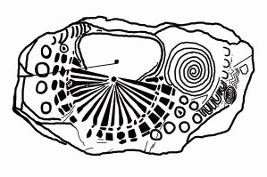
Knowth Kerbstone 15. Sketch by B.L. Freeborn.
© 2016 B. L. Freeborn
How cool would it be if a map from when the glaciers still covered Canada existed? It would show the Laurentide Ice Sheet and the lake that would eventually become Hudson Bay. Would it look just like this 5000 year old artwork from Knowth, Ireland known as Kerbstone 15?
The map shows the North Pole and its rays fanning out. The symbol on the right suggests the inscription tells of the world turning.
The line from the center towards the notch-out on the left is a line drawn from its center (magnetic north for the time period) towards Knowth, Ireland.
The monument of Knowth when seen from the air shows a small round mound overlapping the main structure or a comet impacting the planet.
See more at:
http://www.knowth.com/knowth-kerbstone15.htm
http://www.megalithicireland.com/Knowth.htm

Knowth Kerbston 15. Photo by Ken Williams.

Knowth Kerbstone 15. Photo by Megalithic Ireland.

Hello mate nice blog